Blue Range Hut Recreation area
Location Information
Telephone
6205 8794
Sat Nav Coordinate
-35.289683, 148.875871
Campsite Fees Contact Details
Bookings are essential Phone 6205 8794
Road Access
Unsealed Gravel Road Surface
Parking Area
Some Suitable Grass Areas Available
Big Rigs
Unknown - if there is room to maneuver a big rig successfully
Power Available
No onsite mains power available
Toilets
Yes - At least one public toilet block available
Wheelchair Accessible Toilets
Yes - public toilets with wheelchair access available
Dump Point
No black water dump point
Rubbish Bins
No rubbish bins onsite - So PLEASE Take your rubbish with you when you leave
Drinking Water
No drinking water onsite - Bring your own fresh water with you
Shade
Yes - Quite a few Shady Spots to select from
Picnic Tables
Yes - At least one Picnic Table located here
Fixed Fire places
Yes - At least one fixed fireplace onsite - Remember to bring your own supply of firewood
Pet Friendly
Yes - Dogs are Permitted Conditions Apply
Childrens Playground
No playground infrastructure onsite
Short Walks
Yes - Room to stretch your legs on short walks
Fishing
No fishing spots within easy walking distance
TV Reception
Unknown if you can get a TV signal here
Mobile Phone Reception
Unknown if you can get a mobile signal here
Internet Access
Unknown if you can recieve a mobile phone Internet signal here
Facilities Available
Camping Info
Historic Camping in Uriarra Forest ACT
Explore the Secluded History of Blue Range Hut in the Australian Capital Territory
Nestled deep within the fragrant pine plantations of the Uriarra Forest, the Blue Range Hut Recreation Area offers a unique camping experience that blends serenity with a fascinating chapter of Australian history. Located just a short drive west of Canberra, this site is a hidden gem for campers seeking a rustic escape without venturing too far from the capital. The recreation area is centred around the heritage-listed remains of a World War II Italian internment camp, providing visitors with a tangible connection to the past while they enjoy the tranquility of the bush.
The campground itself is spacious and grassy, set within a large clearing surrounded by tall pine trees that offer excellent wind protection and shade. The centrepiece of the site is the Blue Range Hut, originally the galley for the internment camp. While the hut is unfurnished and basic, it can be hired for events or shelter, featuring a large open fireplace that adds to the rustic charm. Surrounding the hut, unallocated camping is available, allowing you to set up your tent, camper trailer, or caravan in a spot that suits you best. The area is renowned for its peaceful atmosphere, making it an ideal destination for families, solo travellers, and small groups looking to disconnect from the hustle of city life.
Blue Range Hut Recreation Area is a gateway to outdoor adventure in the Brindabella region. It serves as an excellent base for exploring the northern Namadgi National Park and the surrounding Uriarra Forest. One of the most popular activities here is the hike to the Sherwood Homestead ruins. This moderate walk takes you through beautiful eucalypt forest and pine plantations, rewarding you with the historic remnants of the homestead and spectacular displays of daffodils in spring. For those who prefer a more relaxed pace, the campground is perfect for birdwatching, reading by the fire, or simply soaking up the sounds of the forest.
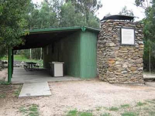
Facilities at Blue Range are basic, reflecting its remote and rustic nature. Visitors will find wood-fired barbecues and communal fire pits, which are perfect for cooking up a camp oven dinner under the stars. There are also picnic tables and pit toilets on-site. However, campers must be self-sufficient; there is no drinking water or electricity available, so you must bring your own supply. Importantly, this is one of the few campgrounds in the region that is dog-friendly, meaning your four-legged companions are welcome to join the adventure, provided they remain on a leash.
Whether you are a history buff, a hiking enthusiast, or simply someone looking for a quiet night by a campfire, Blue Range Hut Recreation Area offers a memorable escape in the heart of the ACT high country. Bookings are essential, so plan ahead to secure your spot in this historic pine forest retreat.
Location & Contact
Name: Blue Range Hut Recreation Area
Address: Blue Range Road, Coree, ACT 2611, Australian Capital Territory
Website: Parks ACT - Blue Range Recreation Area
GPS Coordinates: -35.289903, 148.875698
Map Location
Site Information
- Suitable For: Tents, Camper Trailers, Small Caravans, Motorbikes. (Not suitable for large rigs due to access road).
- Road Access: Unsealed gravel road (Blue Range Road). Generally accessible by 2WD in dry weather; 4WD recommended in wet conditions or for towing.
- Site Surface: Grass and dirt clearing.
- Pet Friendly: Yes (Dogs allowed on leash).
Facilities & Activities
Facilities Available:
- Pit Toilets (Drop toilets)
- Wood Fire Pits (BYO Wood)
- Gas Barbecues
- Picnic Tables
- Communal Shelter (The Hut - requires specific booking/hire)
- Note: No Electricity, No Showers, No Bins (Take your rubbish with you).
Essentials to Bring:
- Drinking Water (No water supply on site)
- Firewood (Collection from forest is prohibited)
- Rubbish Bags
- Toilet Paper
Activities:
- Short Walks: Sherwood Homestead Walk (approx. 9.8km return), Blue Range walking tracks.
- Fishing: Available nearby at the Cotter River (approx. 10km away).
- Wildlife Viewing: Kangaroos, wombats, and birdlife.
Local Amenities
Local Pubs
The Meating Room
Address: 45 Liardet St, Weston ACT 2611
Approximate Distance: 26 km
Places to Eat
Little Sutton Bakehouse
Address: 150 Cliftongate Rd, Sutton (or nearest cafes in Weston Creek)
*Recommendation: Weston Creek has the nearest full range of cafes.*
Address: Cooleman Court, Weston ACT 2611
Approximate Distance: 25 km
Local Attractions
Sherwood Homestead Ruins
Address: Uriarra Forest (Walk-in access from Blue Range)
Approximate Distance: 3 km (Hike)
Cotter Dam & Discovery Playground
Address: Cotter Rd, Stromlo ACT 2611
Approximate Distance: 12 km
Mount Stromlo Observatory
Address: Cotter Rd, Weston Creek ACT 2611
Approximate Distance: 18 km
Alternate Caravan Parks
Cotter Campground (ACT Parks)
Address: Cotter Rd, Stromlo ACT 2611
Approximate Distance: 12 km
Canberra Tourist Park
Address: 7 Old Well Station Rd, Watson ACT 2602
Approximate Distance: 38 km
Alternate Free / Low Cost Camps
Coree Campground (Brindabella National Park)
Address: Brindabella Rd, Coree ACT 2611
Approximate Distance: 15 km
Note: Booking fee may apply, very basic facilities.
Anderson VC Rest Area
Address: Federal Highway, Lake George NSW (Northbound)
Approximate Distance: 55 km
Dump Points
Exhibition Park in Canberra (EPIC)
Address: Flemington Rd, Mitchell ACT 2911
Approximate Distance: 35 km
Cotter Campground Dump Point (Check availability)
Address: Cotter Road, Stromlo ACT
Approximate Distance: 12 km
Nearest Petrol Station
7-Eleven Weston
Address: Brierly St, Weston ACT 2611
Approximate Distance: 25 km
Drinking Water Resupply
Cotter Avenue Recreation Area
Address: Cotter Road, Stromlo ACT 2611
Approximate Distance: 12 km
Public Toilets
Cotter Reserve Public Toilets
Address: Cotter Road, Stromlo ACT 2611
Approximate Distance: 12 km
Seasonal Weather Forecast: Coree, ACT
Summer (Dec - Feb): Warm to hot days with cool nights. Average Temps: 12°C - 28°C. High fire danger risk.
Autumn (Mar - May): Mild days, turning cold. Beautiful foliage in the area. Average Temps: 6°C - 20°C.
Winter (Jun - Aug): Cold, frosty mornings, potential for snow on nearby peaks. Average Temps: 0°C - 12°C.
Spring (Sep - Nov): Fresh and green, wildflowers (daffodils at Sherwood). Average Temps: 5°C - 22°C.
Map
Reviews (0)