Hattah-Kulkyne National Park Camping Area
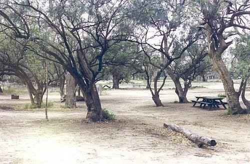
The Hattah-Kulkyne National Park Camping Area has lovely walks through the Mallee with plenty of bird life and gorgeous flora. It's a semi-desert national park, and very flat with lots of Emus, Kangaroos, Possums etc. There are a a few separate Camping areas to choose from, each campground has toilet blocks.
Location Map
Hattah-Kulkyne National Park Camping Area location map
Address
Unnamed Dirt Road, Hattah, 3501, Victoria
Sat Nav Coordinate
-34.752817,142.34319
Suitable for
Caravans and Motorhomes
Tags
Road Access
Unsealed Gravel Road Surface
Parking Area
Gravel Surfaced Area
Elevation above Sea Level
46.8 meters
Drive through site
Yes - Some Drive through sites available
Big Rigs
Unknown - if there is room to maneuver a big rig successfully
Power Available
No onsite mains power available
Toilets
Yes - At least one public toilet block available
Dump Point
No black water dump point
Rubbish Bins
No rubbish bins onsite - So PLEASE Take your rubbish with you when you leave
Drinking Water
Creek or River Water is within walking distance
Shade
Yes - Quite a few Shady Spots to select from
Picnic Tables
Yes - At least one Picnic Table located here
Fixed Fire places
Yes - At least one fixed fireplace onsite - Remember to bring your own supply of firewood
Fixed BBQ's
Yes - At least one BBQ facility is available
Childrens Playground
No playground infrastructure onsite
Short Walks
Yes - Room to stretch your legs on short walks
Fishing
Yes - Some Fishing spots within walking distance
TV Reception
Unknown if you can get a TV signal here
Mobile Phone Reception
Unknown if you can get a mobile signal here
Internet Access
Unknown if you can recieve a mobile phone Internet signal here
Unique Pageviews
3,261
Facilities Available
 ,
,  ,
,  ,
, 
Camping Info